
Are you a Carolina Beach native or just visiting for the first time? Either way, here’s a list of some spots you won’t want to miss. My Aunt and Uncle moved to Wilmington, North Carolina and I can personally vouch for the fact that this area is a paradise to explore by boat.
However, it’s not all fun and games in this beautiful spot. The shifting tides create lots of sandbars to pull up and beach on. Just keep an eye on your depth finder—and don’t venture beyond your comfort zone.The waters in this area can be tricky to navigate safely (more on that later). My Uncle also said I should warn you all about all the alligators, snakes and man eating bugs! “It’s a very dangerous place hence the name cape FEAR.”
Anyway, if you’re wondering where to drop anchor, grab food, hunt for shells, or just cruise and relax—I’ve got you covered. For each destination, you’ll find:
- Why go
- What to do
- A local tip
- Navigation difficulty: 1-3
- Distance (from FBC Carolina Beach)
- Link to Save it in Argo
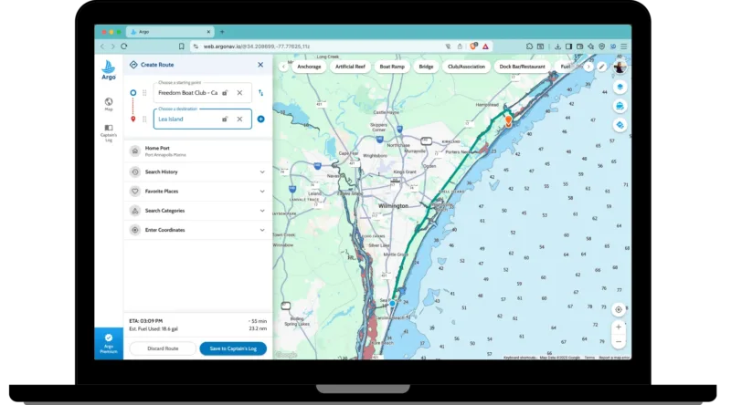
If you open the link, it’ll take you to Argo’s web app. From here you can log in and save the place to your Captain’s Log to visit later. The web app automatically syncs with the mobile app so it’ll be ready on your phone or tablet when you hit the water.
We’ve recently partnered with Freedom Boat Club Carolina Beach to offer members Argo Premium. Their marina will serve as our starting point for estimating distance and travel time. They offer great dayboats—like the Scout 210 Dorado, perfect for family outings, island hopping, and dock-and-dine adventures.
⚠️ Safety Note About Inlets
I want to reiterate that many of the inlets around Carolina Beach—like Mason’s, Rich’s, and even parts of Lea Island—are beautiful but not beginner-friendly. Currents, shifting sandbars, and lack of markers can make them risky. If you’re unfamiliar with the area or boating tides, stick to ICW routes, back channels, or get advice from local captains or your FBC trainer.
Argo’s autorouting and depth overlays are great tools for trip planning—but conditions change quickly. We’ll soon be crowdsourcing more up-to-date depth data from local boaters, but for now, use Argo’s depth info as a helpful starting point, not a guarantee.
Top Boating Stops for Anchoring + Adventure:
Keep in mind that these areas can be very tricky to navigate with the shallow waters and constantly changing tides and currents. Be sure to talk with locals or your FBC trainer for the latest conditions.
Shark Tooth Island
Navigation difficulty: 1/3
Why go:
Shark Tooth Island is a favorite local spot for treasure hunters of all ages. These spoil islands, formed from dredging in the late 1800s, are known for fossilized shark teeth—and if you’re lucky, even prehistoric finds like megalodon teeth or old artifacts from the colonial, Civil War, or Native American eras.
What to do:
Arrive by boat and explore the exposed sandbars at low tide. Scan the shoreline and dig lightly in the sand—some boaters come back with handfuls of fossilized shark teeth.
A local tip:
It’s not a single island, but a chain of spoil islands. Use Argo to navigate to the spots locals know yield the best finds.
Distance (from FBC Carolina Beach): 8.8 nm
Masonboro Island (North End)
Navigation difficulty: 2/3
Why go:
Masonboro Island is the largest undisturbed barrier island along the southern North Carolina coast, located about five miles southeast of Wilmington. It offers pristine beaches, diverse habitats, and nesting grounds for loggerhead and green sea turtles. As part of a protected reserve, the island feels truly untouched with miles of ocean beach on one side and calm sounds and marshes on the other.
What to do:
Arrive by boat and land along the north or south sound side of the island. Walk the trails that cross to the ocean beach, or stroll for miles along the shoreline. Explore the salt marshes, watch for birds, search for shells, or just relax with a private beach setup. Primitive camping is allowed (in previously used spots), so it’s easy to turn this into an overnight adventure.
A local tip:
The sound side can be shallow and the approach tricky depending on the tide. Keep an eye on your depth-finder. Argo can show depth data, but real-time readings only work if your boat has NMEA connected.
Distance (from FBC Carolina Beach): 9.8 nm
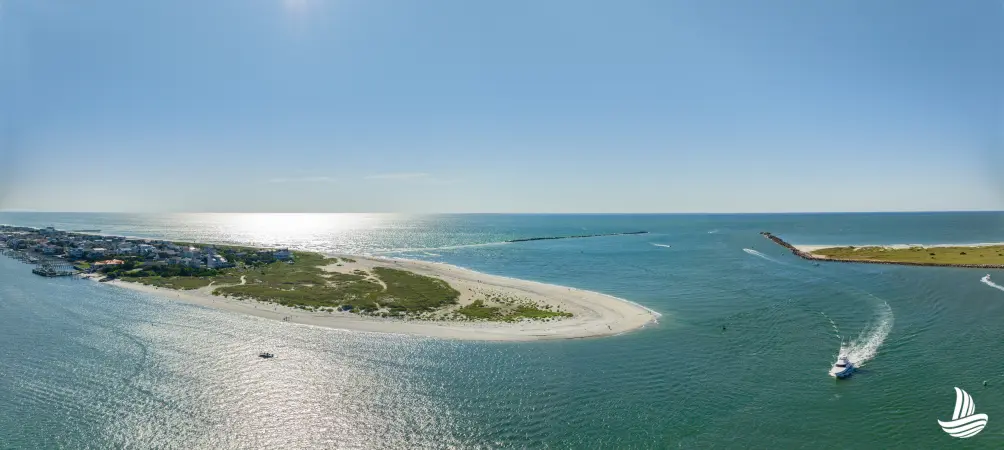
Lea Island
Navigation difficulty: 3/3
Why go:
Lea Island is a 6-mile-long uninhabited barrier island stretching north toward Topsail. It’s a haven for wildlife—during spring and summer, loggerhead sea turtles nest here, along with hundreds of terns, skimmers, and thousands of migratory shorebirds. With no buildings or roads, it offers a wild, untouched feel just minutes from the mainland.
What to do:
Beach your boat on the sound side and explore the island on foot. Walk the shoreline, pack a picnic, or stay all day soaking in the solitude. Keep an eye out for dolphins playing just offshore.
Local tip:
Conditions change often in Howard Channel, and it can get shallow quickly. If you can, ask an FBC trainer or local boater to share their preferred route.
Distance (from FBC Carolina Beach): 23.2 nm
Rich’s Inlet
Navigation difficulty: 3/3
Why go: Rich’s Inlet is a naturally dynamic, undeveloped waterway separating Figure Eight Island and Lea Island. While beautiful and wild, it’s known for drastic changes and challenging conditions, making it a spot only for very experienced boaters.
What to do: Due to shifting sandbars and strong currents, this inlet is mostly avoided by most boaters. If you do venture here, only pass through during favorable daylight conditions and with local knowledge.
A local tip: The main channel shifts dramatically—sometimes every 15 years! The sandbars move constantly, so always check recent conditions. Avoid entering during rough winds, tides, or swells.
Distance (from FBC Carolina Beach): 18 nm
Mason’s Inlet
Navigation difficulty: 3/3
Why go: This undeveloped inlet between Wrightsville Beach and Figure Eight Island is stunning but can be extremely dangerous. The natural beauty can be deceiving—strong currents, shifting sandbars, and a lack of navigation markers make it a challenge even for experienced boaters.
What to do: Due to safety concerns, most boaters avoid the inlet itself. Instead, explore calmer backwaters and anchorages in nearby sound or marshy areas west of the inlet, like Banks Channel or Pages Creek off the ICW.
A local tip: Mason’s Inlet is not recommended for beginners or unfamiliar boaters. If you’re nearby and curious, stay on the ICW and explore safer areas. This caution is well founded—as seen in this video of a boat capsizing in the inlet surf. Use Argo’s charts to plan routes, but rely on your boat’s depth finder and local knowledge for real-time conditions.
Distance (from FBC Carolina Beach): 13.4 nm
Water-front Dining and Downtown Areas to Explore
Riverlights District
Why go: While there’s no public dock in Riverlights, this area is home to two of our favorite restaurants—perfect for a great meal after a day on the water.
What to do: Dock your boat at a nearby marina (you may have to Uber) or trailer it and drive over. Then head to Smoke on the Water for coastal American and seafood dishes with sunset views from their riverfront deck, or to Girls with Dough for casual pizza and pasta in a relaxed family-owned riverside setting.
A local tip: At Girls with Dough, you can’t go wrong with the pepperoni—but try the lasagna if pizza’s not your thing. At Smoke on the Water, we recommend the shrimp tacos.
Distance (from FBC Carolina Beach): 11.1 nm
Save Smoke on the Water in Argo
Downtown Wilmington
Why go: Want to mix boating with culture, shopping, and nightlife? Dock downtown and explore this charming Southern riverfront city. Downtown Wilmington—affectionately called “Wilmy” by my uncle’s family—is full of character,
What to do: Walk the scenic Riverwalk, browse local shops, visit museums, and grab a bite or cocktail at one of many waterfront spots.
Local tip: Transient slips are available at Port City Marina (4.9 stars on Argo) and Cape Fear Marina, both walkable to the Riverwalk. Use Argo to book slips at Port City before arriving.
Distance (from FBC Carolina Beach): 16.7 nm

Southport Restaurants
Why go: This charming harbor town looks like it belongs on a postcard—complete with seafood spots, historic homes, and oak-lined streets.
What to do: Dock at Southport Marina or one of the nearby day-use slips, then walk to popular restaurants like Provision Company or Fishy Fishy Café for fresh seafood and harbor views.
Local tip: The Cape Fear River can get choppy with wind and tide. Use Argo’s autoroute to time your trip and check conditions before heading in. Argo shows wind, tide, current, and wave height predictions forecasts for up to 7 days.
Distance (from FBC Carolina Beach): 12.2 nm
Final Thoughts
There’s so much to explore around Carolina Beach—from bustling downtowns to peaceful nature reserves. Just remember: conditions change, tides shift, and local knowledge matters. Use Argo to plan ahead and stay flexible out there. Connect with your boat’s NMEA network to get real-time depth info within your app. Make use of the current, tide and wave height forecasts. And don’t forget to save all of these places to your Captain’s Log to reference later!