A Landlubber’s Guide to Nautical Measurements
Nearly every driver on the road is familiar with miles per hour (MPH), statute miles, and miles per gallon (MPG). Those accustomed to the metric system use kilometers (km), kilometers per hour (KPH), and the metric equivalent of MPG (L/100 km). On the water, though, those predominantly land-based units add unnecessary complexity while suffering lost relevance and accuracy. Most weekend boaters have probably heard expert mariners down on the fuel dock referring instead to knots, nautical miles, and gallons per hour (GPH) and naturally wondered what the logic is behind having a completely different set of measurements on the water. Wonder no longer.
Knots and Nautical Miles: A Seamless Relationship
The nautical mile is a unit of distance tied directly to the Earth’s geometry. It is based on one-sixtieth of a degree of latitude or one minute of arc, roughly equivalent to 6,076 feet. This is ideal for marine navigation, which is grounded in the coordinate system of latitude and longitude. Unlike the statute mile, which is fixed at 5,280 feet and lacks any inherent connection to the Earth’s curvature, the nautical mile ensures distances on the globe are consistent and relevant for travel.
For mariners, the practical beauty of the nautical mile is that it easily translates to speed, time, and location calculations. Since navigational charts are scaled to nautical miles, calculating distance and speed becomes a seamless process, avoiding unnecessary conversions and minimizing the ever-present risk of errors.
But what about knots? Knots are the unit used to measure speed on the water, and the term originates from the chip log, an ancient device used to determine a ship’s speed. Sailors would toss the chip log—a wooden board attached to a line with evenly spaced knots—overboard. As the ship moved forward, the line would pay out over the rail for a specific period of time, typically measured using a “sandglass” (hourglass). The number of knots that passed over the rail during the interval represented the ship’s speed in nautical miles per hour—hence, “knots” rather than “nauts.”
Today, the knot remains the standard measure of speed on the water, equal to one nautical mile per hour, simplifying navigation and the calculations it would otherwise require. Since nautical miles directly correspond to the Earth’s geometry and one knot corresponds to one nautical mile per hour, these units can be easily applied to time, fuel, ETA, and location calculations without complicated conversions or other unnecessarily error-prone processes.
Interestingly, the term “log” or “logbook” also comes from the tradition of the chip log. This is one of those situations in which nautical terms have intersected with common language. The speed of the vessel was recorded in the “log book.” Now the ship’s log contains a record of nearly everything that happens aboard ship. These days most situations that require recording are “logged,” whether on land or sea. It’s in homage to that entire history that Argo has within it a “Captain’s Log.” We’re hip to the lingo, you know.
When Statute Miles and MPH Are Useful
While knots and nautical miles dominate open water navigation, there are situations where statute miles and MPH remain practical. On the Intracoastal Waterway (ICW), the Western River System, the Gulf Intracoastal Waterway (GIWW), and most U.S. navigable river and canal systems, distances are often marked in statute miles. Inland navigational charts, cruising guides, and regional navigation aids may reference specific mile markers, and local features such as bridges, locks, and marinas are typically “found” by their statute mile location.
In these settings, knowing distances in statute miles and speed in MPH can provide more relevant and actionable information for timing arrivals, locating bridges, locks, and marinas, or coordinating with shore-based authorities. Additionally, some older charts and guides still reference statute miles, so maintaining fluency in both systems is advantageous.
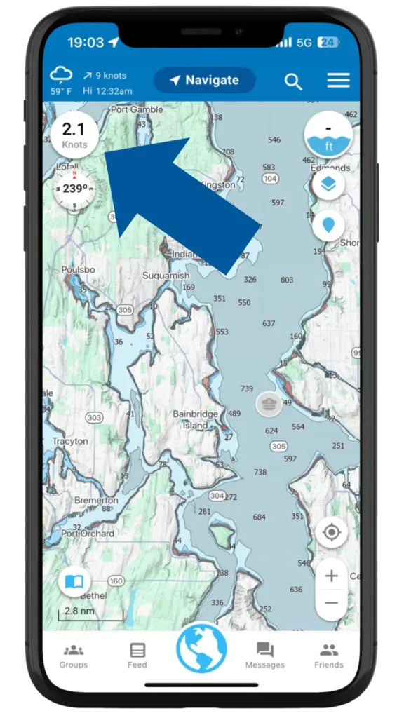
Useful Argo Hint: Tap the speedometer in the upper left to quickly switch between unit types (see image).
GPH vs. MPG: The Illusion of Information
MPG (and its metric counterpart, L/100 km) presumes a stable, predictable surface (a paved road) and minimal environmental variables. The water offers neither. Wind, weather, currents, waves, and hull fouling are just a few of the forces that can dramatically impact a boat’s fuel efficiency, making MPG (distance per fuel unit) a far less meaningful or accurate metric than monitoring fuel flow over time.
GPH provides accurate, fixed, and actionable data, allowing the savvy mariner to know with great confidence how many gallons of fuel are burned per hour at various engine revolutions per minute (RPM). This makes it a simple matter to reliably plan vessel range, monitor engine performance, and adjust speed to maximize efficiency on long voyages.
Safety at Sea: Why Precision Matters
At sea, far from shore, ambiguity can be dangerous. Misjudging speed, distance, or fuel consumption can have serious consequences, particularly when unexpected weather, strong currents, or mechanical issues arise. Knots, nautical miles, and GPH offer clear, useful data that aligns with the latitude-longitude grid, navigational charts, real-world conditions, and best practices, enabling mariners to make informed, precise decisions on the water.
On the other hand, miles/MPH, while perfectly measurable at sea, are less practical for navigation. Marine charts are scaled in nautical miles, and calculating distances and speeds in statute miles introduces unnecessary conversions and potential for error. Knots and nautical miles, by contrast, are directly aligned with the latitude-longitude grid, maintaining a seamless connection between speed, distance, positional accuracy, and Earth’s natural geometry.
A Quick Primer for the Statute-Mile-Minded
If knots, nautical miles, and GPH feel like an alien language to you, you’re certainly not alone. For those accustomed to statute miles and MPH, here’s a simple way to wrap your head around the conversion:
- Knots to MPH: 1 knot is roughly 1.15 MPH. Multiply knots by 1.15 to get an approximate speed in miles per hour.
- Nautical Miles to Statute Miles: 1 nautical mile equals approximately 1.15 statute miles. Multiply nautical miles by 1.15 to convert to statute miles.
- GPH to MPG: GPH measures fuel consumption over time, not distance. However, once you know your speed in knots and your GPH, you can estimate range by dividing your speed (in knots) by GPH, then converting to statute miles. This is a rough approximation and not particularly reliable in varying sea conditions.
Embracing “Sea Units” with Confidence
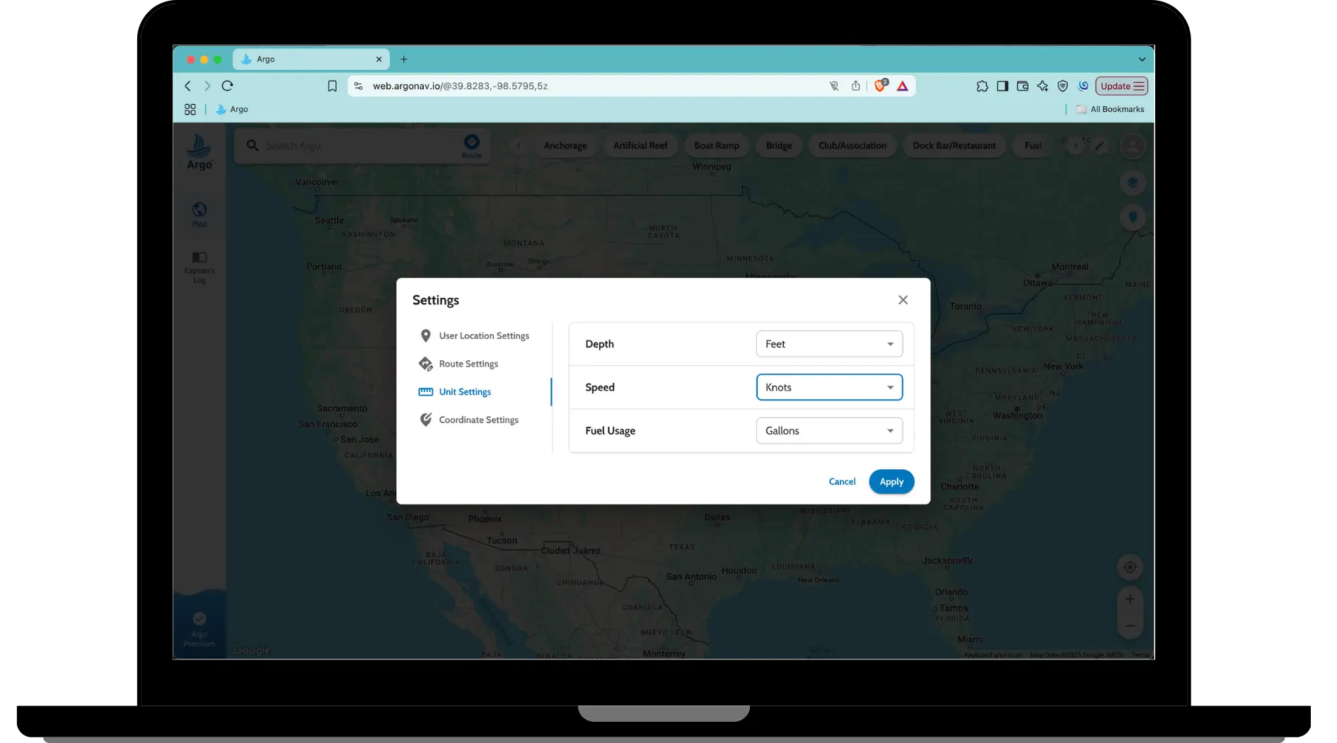
For those just beginning their journey on the water, navigation apps like Argo can easily and seamlessly handle conversions between knots, nautical miles, and GPH fluidly and accurately, making the transition easier for less-adept mariners. Over time, however, most find themselves gravitating toward using these “sea units” as their primary units of measure aboard.
After all, with sufficient time on the water, these benchmarks will become second nature, and mariners will appreciate the intuitive and practical nature of the measurements, no matter how unfamiliar they may seem at first. As with any “language,” there are just some terms which defy translation, and the language of measurements at sea is no different. Furthermore, let’s be honest, we all want to sound salty when sharing our stories of great adventure at the dock bar.
Conclusion
For those making the same short trips on small lakes year after year, understanding knots, nautical miles, and GPH may feel (and rightly so) like little more than maritime trivia. For mariners making serious passages, however, these units become essential tools for precise navigation and fuel management. Knots, nautical miles, and GPH provide a practical framework that aligns with the natural geometry of the Earth and the variable conditions of the water and best practices. Embracing these maritime standards isn’t about sounding salty at the dock—it’s about ensuring that your vessel, your crew, and your data are all on the same page and you arrive at your intended destination without undue adversity. After all, a mariner’s best pub stories should be mostly lies….