How Boaters Can Help Keep Gulf Coast Waters Healthy
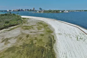
From the helm, Perdido Bay looks wide open and inviting. Clear blue water, sandy bottoms, and calm bays make it perfect for anchoring and exploring. This area has become a popular destination for Gulf Coast boaters. On busy holidays, it’s not unusual to see more than 500 boats gathered around an island at once, just some of the nearly 8 million visitors Baldwin County sees each year.
Beneath the surface, these beautiful waters are fragile. Seagrass meadows and marshes form the backbone of the northern Gulf Coast’s ecosystems. They provide nursery habitat for fish, shrimp, crabs, and countless other marine species. Birds and other wildlife rely on healthy nearshore habitats to survive. Boat traffic—even unintentional activity like prop scarring, wakes, or drifting too close to nesting areas—can disrupt these critical habitats.
Knowing where sensitive areas lie helps boaters keep our favorite destinations healthy and enjoyable for everyone. Argo is taking steps to make this easier for everyone. Keep reading to learn more.
What Is Seagrass and Why It Needs Protection
Beneath the calm waters of many Gulf Coast boating hotspots (such as Perdido Bay, Mobile Bay, and Mississippi Sound) lie seagrass meadows, also called submerged aquatic vegetation (SAV). These underwater plants may seem unimportant, but they play a big role in coastal health.
Why Seagrass Matters:
- Nursery habitat: Juvenile fish, shrimp, crabs, and other invertebrates hide and feed here.
- Food and shelter: Birds and larger marine mammals rely on nearby areas for resting and foraging.
- Shoreline protection: Dense roots trap sediment and reduce erosion from tides and boat wakes
- Water quality: Seagrass filters nutrients and sediments, keeping water clearer and healthier.
- Carbon storage: Like marshes and mangroves, seagrass captures carbon, helping offset climate impacts.
Why Seagrass is Vulnerable:
- Propeller scars from boats can leave long-lasting damage.
- Strong wakes can uproot plants or stir up sediment, blocking sunlight.
- Pollution can reduce water clarity and harm these delicate meadows.
Quick Tip for Boaters: Avoid shallow areas with visible grass, reduce speed near marshes, and watch for wildlife. Small steps make a big difference.
Why No Wake and No Motor Zones Exist
As mentioned above, it’s not easy to tell from above the water which areas are fragile and need protection. No-wake and no motor zones protect both people and sensitive habitats, including seagrass beds, marsh edges, and nesting grounds.
How These Zones Help:
- Reduce erosion: Slower speeds limit wakes that wash away shorelines.
- Protect vegetation: Propeller-free zones prevent scarring of underwater plants.
- Limit wildlife stress: Avoiding close approaches keeps birds and mammals safe.
- Protect people: Preventing boats from running aground and helping to reduce unsafe interactions with other boaters and swimmers.
“No wake and no motor zones aren’t arbitrary restrictions—they’re in place to protect both people and sensitive habitats,” says Katie Baltzer, Coastal Projects Manager with The Nature Conservancy. “We help define sensitive areas using surveys, aerial imagery, and ecological studies, then work with municipalities and enforcement to set clear guidelines for boaters.”
Quick Tip for Boaters: Pay attention to posted markers and slow down in designated zones to give wildlife space.
A Conservation Partnership Focused on Perdido Bay
To help boaters navigate these areas responsibly, Argo has partnered with The Nature Conservancy (TNC) to bring verified conservation data directly onto marine charts. This helps boaters avoid accidental damage by making it easier to see where seagrass meadows, no wake zones, and other protected areas exist.
The initial focus is on Perdido Bay and the Lower Perdido Islands, where recreational boating is most concentrated. Over time, conservation data will expand into Mobile Bay and Mississippi Sound, creating a phased approach that balances coverage and usability.
Argo has begun integrating the data and it will be available for use in Summer 2026. Our first step is to add protected zones on the charts as clearly defined polygons showing no wake and no motor areas, sensitive habitats, and other priorities. Next, we plan to add popups to provide additional context, such as why an area is protected or what species it supports. Both of these efforts will give boaters simple, actionable guidance without overwhelming detail.
This is part of a broader effort on the part of TNC to protect the Perdido Bay. Learn more about their efforts here.
What Boaters Will See on their Charts
Boaters using Argo can view sensitive areas in real time. Features include:
- Seagrass and sensitive habitat zones: Clearly marked underwater meadows and wildlife areas.
- No wake and no motor areas: Zones where slower speeds or non-motorized travel protect shorelines and wildlife.
- Environmental overlays: Visual guides to fragile areas.
- Contextual alerts or popups: Gentle notifications explain why a zone matters and how to minimize impact.
These tools are designed for education, not enforcement. All will be available in the free version of Argo. The goal is simple: boat safely, enjoy the Gulf Coast, and help keep these waters healthy for wildlife and future visits.
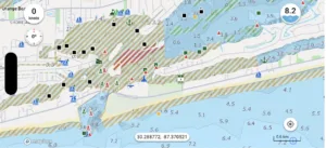
Guide
- Brown = No wake zones
- Red No motor zones
- Green = Seagrass
How Technology Can Support Responsible Boating
Conservation and recreation don’t have to compete. With timely, accurate information, boaters can enjoy the water while protecting the habitats and wildlife that make the Gulf Coast special. Tools that highlight sensitive areas and provide context turn everyday boating into a more informed, mindful experience.
“By combining science with practical tools, we can empower boaters to enjoy these waters responsibly while supporting long-term habitat protection,” says Katie Baltzer, Coastal Projects Manager with The Nature Conservancy.
What Boaters Can Do Today
Protecting coastal waters starts with informed choices. Simple actions make a big difference:
- Learn to recognize seagrass and other sensitive habitats.
- Slow down in shallow areas to minimize wakes and prop damage.
- Respect no wake and no motor zones.
- Use tools that highlight sensitive areas while exploring.
Here at Argo, we’re proud to be one of the tools you can use to stay aware of fragile ecosystems and make informed decisions. We’re honored to be working with such a reputable organization as The Nature Conservancy and thank them for taking the time and effort to gather the information to display in Argo.
Together, we can protect the areas we all love and keep them pristine for years to come. Every mindful choice helps preserve the Gulf Coast for future visits. By combining conservation knowledge with practical tools, boaters, communities, and technology can work together to keep these waters healthy, vibrant, and enjoyable for generations.