What Is SpotOn Fishing?
If you have ever stared at a chart wondering where the fish actually are, you are not alone. That frustration is exactly what SpotOn Fishing was built to solve.
SpotOn Fishing is a fishing-focused navigation and mapping app designed specifically for anglers who want more than basic charts. It combines high-resolution satellite imagery, structure and bathymetric maps, and real community-sourced fishing spots to help anglers make smarter decisions on the water, whether you are fishing inshore, offshore, or freshwater.
Unlike traditional navigation apps that prioritize routes and waypoints, SpotOn is built around one central question: how do I maximize my production on a fishing trip?
Built by Anglers, Not Just Developers
One of the biggest things that sets SpotOn Fishing apart is who it is built for and who it is built by. The platform was created by anglers who understand that fishing decisions are rarely simple. Tide, structure, depth, weather, and most importantly, local knowledge all play a role.
Because of that, SpotOn focuses on practical, real-world fishing intelligence instead of cluttered charts or generic map layers. Every feature is designed to put anglers on new fishing spots quickly, clearly, and accurately.
High Resolution Satellite and Structure Maps
SpotOn Fishing offers detailed satellite imagery and structure maps that help anglers see what is below the surface before they ever drop a line. These maps are especially valuable for:
- Identifying reefs, drop-offs, channels, and ledges
- Finding a structure that holds fish in both shallow and deep water
- Scouting unfamiliar areas with confidence
For inshore anglers, satellite imagery reveals grass lines, sandbars, and oyster beds. Offshore anglers can analyze bottom structure and contours. Freshwater anglers can pinpoint humps, points, and submerged features that do not always show up clearly on traditional maps.
Centimeter Accurate Bathymetric Data
Depth matters, especially when fish are holding tight to specific contours. SpotOn Fishing provides centimeter-accurate bathymetric data, giving anglers an extremely precise view of underwater terrain.
This level of accuracy allows anglers to:
- Track subtle depth changes that attract fish
- Fish structure more precisely instead of guessing
- Adjust tactics based on exact bottom features
Instead of broad depth ranges, anglers get fine detail that helps turn almost spots into productive ones.
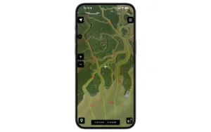
Screenshot in the app of community routes.
Real Fishing Spots Powered by the Community
SpotOn Fishing is not just about maps. It is powered by anglers who share real fishing spots and insights based on actual experience.
Community-driven data helps users:
- Discover productive fishing areas faster
- Learn what spots are consistently producing
- Benefit from shared local knowledge
This approach turns the app into more than a tool. It becomes a network of anglers helping each other fish smarter.

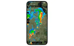
In-App screenshot of live weather, including rain and lightning.
Advanced Weather Overlays for Smarter Decisions
Weather plays a massive role in fishing success, and SpotOn Fishing integrates advanced weather overlays directly into the map experience. Instead of switching between multiple apps, anglers can see conditions layered right over their fishing spots.
These overlays help users understand how weather and conditions like sea surface temperature interact with structure and depth, making it easier to decide when to go, where to focus, and when conditions are not worth the trip.
In-app screenshot of lake structure.
Inshore, Offshore, and Freshwater in One App
Many fishing apps focus on just one environment. SpotOn Fishing is designed to support anglers across all major fishing styles.
- Inshore fishing, including flats, oyster beds, grass lines, and tidal structure
- Offshore fishing, including reefs, drop-offs, and deep structure
- Freshwater fishing, including lakes, rivers, points, and submerged features
No matter where you fish, the app adapts to your needs without forcing you to learn a new platform.
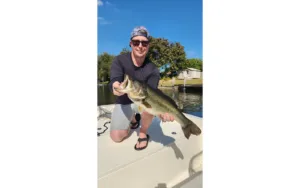
Founder of SpotOn fishing, Nick Gaffney, posing with his catch of the day.
Why Anglers Use SpotOn Fishing
At its core, SpotOn Fishing helps anglers fish with precision instead of guesswork. By combining detailed maps, precise bathymetry, weather insights, and community knowledge, it gives users the confidence to make better decisions every time they head out.
It is not about replacing skill or experience. It is about enhancing them with better information.
If you have ever wondered whether a spot is worth your time or wished you could see beneath the surface before casting, SpotOn Fishing is built for you.