Great news, Captains! Argo has officially integrated Bob423 Tracks into the app. For the uninitiated, these tracks are the “Gold Standard” for navigating the ever-shifting sands of the Atlantic Intracoastal Waterway (ICW).
But before you glue your eyes to the screen and forget the world exists, let’s talk about how to use this tool like a pro—without becoming a “Track-Zombie.”
The Colors of Confidence: Magenta & Orange
To keep things intuitive, we’ve styled these tracks with a bit of history in mind:
- The Magenta Line: As an homage to the classic ICW “magenta line,” Bob’s primary path is displayed in Magenta. Since Argo doesn’t typically display fixed sailing lines, this is your signal that you’re riding with local experts.
- The Orange Paths: Where things get dicey, you’ll see Orange tracks. These are your Alternate Paths—the “Plan B” routes for when shoaling or tides make the main channel a gamble.
Relax! You Don’t Have to “White Knuckle” It
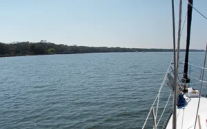
The Atlantic ICW is a masterpiece of American engineering, and for the vast majority of its ~1,000 miles, it’s a wide, deep, and forgiving highway. You do not need to “white knuckle” it with your prow kissing the line through every inch of the Carolinas.
If you’re in a stretch where the natural deep-water channel is a quarter-mile wide and you’ve got 15 feet under the keel, feel free to breathe. Enjoy the ospreys, check your gauges, and let the boat run. You only need to treat the Track like a lifeline when the waterway constricts and the “Trouble Spots” begin to bite.
The “Hold Your Breath” List
In these specific areas, the shoals are real and the margin for error is measured in inches. In these spots, the Magenta line (or those Orange alts) is the difference between a great day and a call to TowBoatUS.
Keep your eyes peeled at:
- The Inlets: Jupiter, Ponce de Leon, Carolina Beach (MM293), Mason (MM280), and New River (MM246).
- The Notorious Cuts: Hell Gate (MM601—don’t hug G89!), Snows Cut, Ashepoo-Coosaw Cutoff (MM516.5), Isle of Palms (MM460), and the Lockwoods Folly area (MM320-321.5).
- The “Changing” Spots: Little Mud River (MM654), Watts Cut (MM503), and Fort Matanzas (MM792—don’t let the ghost of G81D on your charts fool you; it’s gone).
- The “Math” Spots: Jekyll Island (MM683). Watch the wind tides here; a seiche can steal your depth faster than a pirate.
Pro Tip: Before transiting these tight spots, especially if visibility is low, make a Securité call on VHF 13 and 16. Let others know you’re coming through so you don’t meet a 100-foot barge—or another cruiser—in a narrow, shallow spot. Oh, and you might consider making one when approaching the Rock Pile near Myrtle Beach, SC, as well. That’s a terrible place to meet a barge tow coming the other way.
Rule 9: Bob’s Tracks are NOT an Excuse
Following a GPS track is not a valid excuse for ignoring the Inland Rules of the Road’s Narrow Channel Rule. Rule 9 applies to everyone—from tugs and trawlers to sailboats and canoes. Everyone.
The rule states vessels should keep to the outer limit of the channel on their starboard side as is safe and practicable. The reality check: If you’re a sailboat drawing 5 feet and the only safe water is the center of the channel, you have the right to that water. If a Grady White drawing 2.5 feet comes buzzing up, they need to take a number and wait. However, “staying on Bob’s line” isn’t a legal reason to block the channel if there is safe water to your starboard.
The “What if They Don’t Answer?” Protocol
If you hail someone and get nothing but static, it’s time to get loud with the horn. And remember: A horn/whistle blast is a question, not an insult! If someone honks at you, they aren’t “yelling” or being rude—they are asking for an agreement. Don’t flip them the bird; just respond with your own horn.
- One Short Blast: “I intend to leave you on my port side.”
- Two Short Blasts: “I intend to leave you on my starboard side.”
- The Response: If you agree, repeat the signal back. If you don’t agree or the move is dangerous, blow five short, rapid blasts (the Danger Signal).
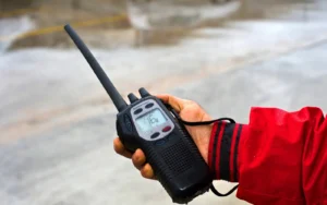
Get Your Ears On
To our sailing friends: if your radio is down in the salon and you can’t hear it at the helm, you aren’t keeping a proper radio watch (required under the rules if you have a VHF aboard at all). If a captain is trying to hail you to coordinate a safe pass and you’re silent, you’re a hazard. If your boat doesn’t have a cockpit radio or remote station, a high-quality handheld VHF is an investment that is not only worth making—it’s required.
The Final Word: Be the Captain, Not the Passenger
Bob423 Tracks in Argo Nav are a hard-won asset—the result of countless hours of “boots on the ground” (or rather, “keel in the mud”) research by a group of committed, qualified mariners. But remember: a GPS track is a tool, not a pilot.
Don’t let the convenience turn you into a Track-Zombie. Use the Magenta line to find the deep water, use the Orange paths to outsmart the shoals, but keep your eyes on the horizon and your hand on the wheel. Bob provides the data, but you provide the seamanship.
Ready to start planning? Head to Map Options > Bob423 Tracks to toggle them on, and we’ll see you out in the deep water.