When you’re navigating in shallow water, a number on the chart can be the difference between a comfortable passage and an unpleasant surprise. That makes an important question worth asking: What does that number actually mean?
A charted depth has to mean something even though the water over the bottom is constantly changing. The answer is to establish a reference water level and describe the depth of water at that level. In U.S. coastal waters, that reference is called Mean Lower Low Water, or MLLW.
The name sounds more complicated than the idea. If a location experiences two low tides in a day (semi-diurnal tides), one will generally be lower than the other. MLLW is based on the average of those lower low waters over many years. Where there is only one low tide each day (diurnal tides), that daily low water is used instead. The result is a consistent low-water reference that lets a chart describe the depth of water at that level, while the tide rises and falls above it.
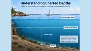
This is one of the things paper charts got right. The chart did not try to predict what the water would be doing when you arrived. It gave you a consistent picture of the depth of water at MLLW, while the tide tables told you what the water was expected to do relative to MLLW. The two pieces of information belonged together, but they remained separate, leaving the interpretation to the mariner.
The tide prediction tells you where the water level is expected to be relative to MLLW at a particular time. Think of MLLW as the chart’s starting line: if the tide is predicted to be two feet above it, and the charted depth is 6 feet, you can expect roughly 8 feet of water—assuming the prediction and the timing are both correct.
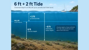
The water level moves with the tides, but the charted depth remains static.
The Tide Is Important. Argo Shows It.
The tide matters enormously. A mariner needs to know not only what the chart says about the bottom, but also what the water level is doing and, when available, what the vessel’s own depth instrument is reporting. Argo therefore provides tide information alongside the chart.
Argo can optionally display its new tide variance gauge alongside the charted-depth gauge. The tide variance gauge shows the predicted state of the tide at the nearest or selected tide station, including the current tidal level and whether the tide is flooding or ebbing.
For vessels that provide depth data to Argo via NMEA, the depth gauge displays the vessel’s actual reported depth. Tide information remains available separately.
That distinction is intentional, and preserving it is important. Argo presents each piece of information according to what it actually represents: charted depth as the depth of water at MLLW, tide variance as predicted tide level above or below MLLW, and NMEA depth as vessel-reported current measured depth. When you have all three, you can compare the prediction with what is actually being measured aboard the vessel. If the charted depth at MLLW plus the predicted tide level does not consistently correspond with the measured depth, that can indicate that the prediction, timing, local conditions, or depth reference do not match reality. Argo gives the mariner the information needed to make decisions without pretending that these different values are the same thing. Can your boat go there now? Maybe. But that’s a decision for a captain, not an app.
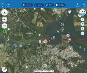
Why Argo Doesn’t Make Charted Depths “Float”
It can be tempting to take the charted depth and the predicted state of the tide and simply combine them, replacing the charted depth with a dynamically changing number. Modern software makes that easy to do, some apps do it, and we get frequent requests to bring the feature to Argo. We won’t do it for the very real risk of blurring a truth with an uncertainty.
Put another way, taking two different pieces of information and collapsing them into one value can make the result look like something it isn’t: a verified and therefore trusted number. Just because two numbers can be added doesn’t mean their sum is useful. The charted depth is established hydrographic information. The predicted tide is a forecast. Actual water levels can differ from predicted levels because of local conditions, and the predicted timing can be off as well. Combining an established fact with an imperfect prediction produces an estimate—not an updated depth measurement.
Consider a charted depth of six feet and a predicted tide level of two feet above MLLW. Those numbers are useful together. A mariner can understand that the water is expected to be approximately two feet above MLLW and incorporate that information into a passage decision. Argo does not change the chart to display eight feet, because doing so would replace the verifiable charted depth with a calculated value based on a prediction. The calculation may be useful to the mariner (most people can do the math in their head), but it does not change what the chart tells us about the depth at MLLW.
That doesn’t mean the predicted tide is irrelevant. Quite the opposite. An experienced mariner can use the charted depth at MLLW as a conservative reference and then consider the additional water predicted to be provided by the tide, taking into account the tidal range, the reliability of the prediction, local conditions, and the consequences of being wrong. In some circumstances, that may make the difference between a prudent passage and one that should wait for more water. For a less experienced mariner, however, treating predicted tide as routinely available under-keel clearance is a very different proposition. The important thing is that the information remains visible so the mariner can make an informed decision appropriate to both their comfort level and the circumstances.
A tide prediction is not a measurement. Actual water levels can differ from predictions because of wind, atmospheric pressure, rainfall, river discharge, recent extreme tide action, and other local conditions. The difference may be insignificant in deep water, but it can become extremely important when a vessel is operating with limited under-keel clearance. The same is true of timing: a prediction that is correct in general can still be wrong for the particular moment that matters to a mariner.
We believe it is impossible to have too much data, but the illusion of data can be quite dangerous on the water. The mariner is better served when the charted depth and tide remain visible as what they actually are: information that can be considered together, rather than a contrived number that preempts the mariner’s better judgment. A feature that presents an estimate as a changing depth may look like a safety feature, but if it obscures the information that actually determines whether a passage is safe, that characterization is difficult to justify.

Argo’s Philosophy
Navigation software should make good information easier to use without making uncertain information appear more certain than it is.
Argo’s approach is straightforward: charted depths remain charted depths, tide information is displayed as tide information, and NMEA depth is displayed as vessel-reported depth when available.
The goal is not to give the mariner a more impressive number or a false sense of security. The goal is to give the mariner better information to make their own best decisions. That’s Argo’s mission.