Once you have created a route using either autoroute or manual route mode, the next step is to take a voyage. You can use the route you created to help you navigate to your destination and get important trip information updated for you along the way, such as ETA and estimated fuel used. You will also create a track of the actual path that you take that can be saved along with your other trip information to your Captain’s Log.
Start Voyage
After creating a route either in autoroute or manual route mode, simply hit ![]() .
.

View Info on Your Voyage
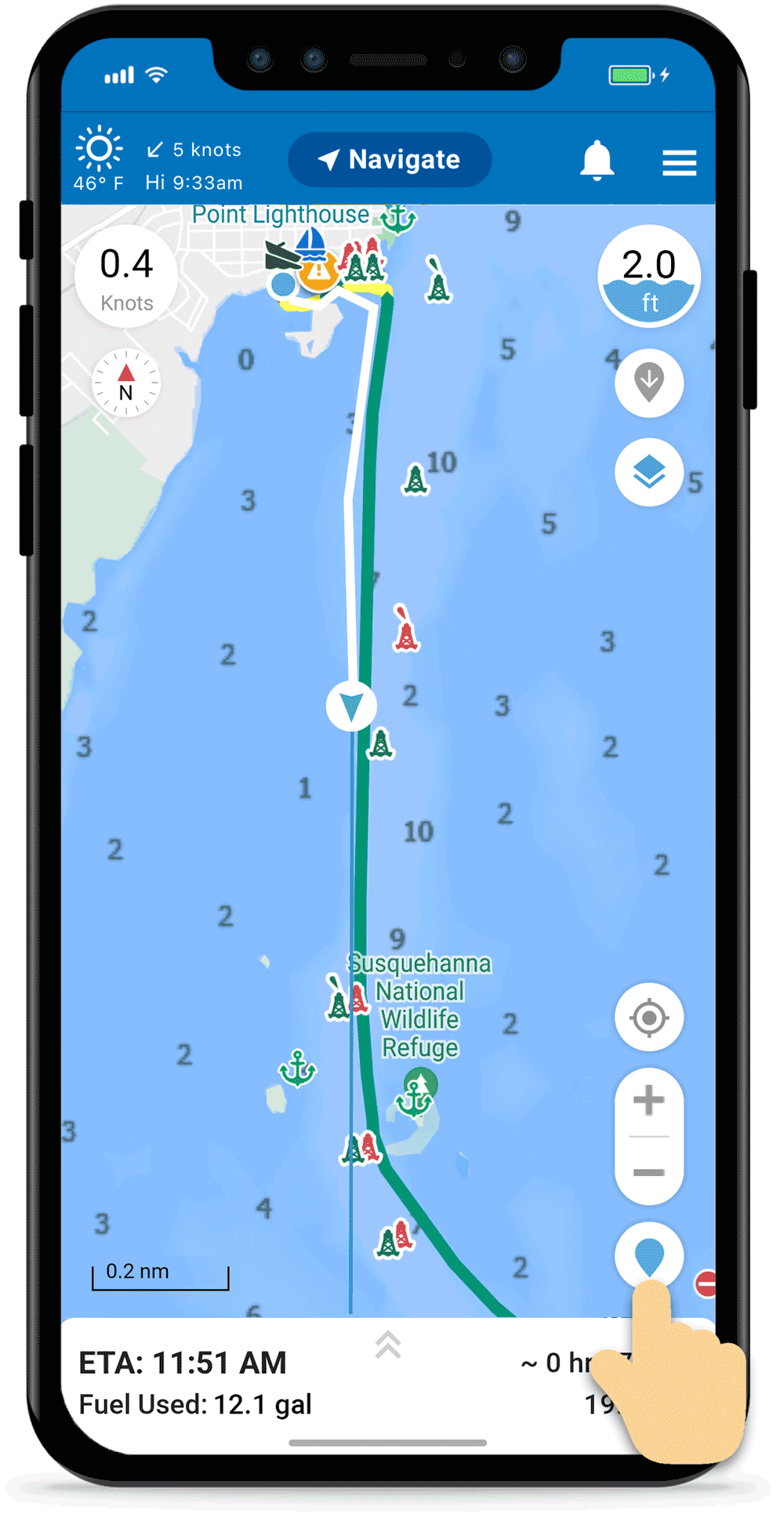
The following information are displayed when on a voyage:
- Route & Track – the route you created (green/yellow/red) and your track (white) are displayed on the map. Your track is updated while enroute.
- Trip Info – ETA, duration, distance and estimated fuel usage are continuously updated while on your voyage.
- Adjust Map – You can pinch or finger tap to zoom the map and adjust your view while enroute to see more or less map data details or move to view different areas on the map.
- Save & Discard Buttons – The Save and Discard Voyage buttons are hidden. To display these buttons tap the grey arrows
 icon above the globe. Tap the arrows icon again to hide them.
Note: You can adjust the map view, units displayed and map data you see during the voyage (depth, buoys, marinas, etc.) by tapping on the Map Options ![]() icon.
icon.

Depth, Speed & Distance
The following navigation features are available while enroute:
- Depth Gauge
 – depth (low-median tide) at your current location in feet or meters. Tap to adjust settings
 - Speedometer
 – current speed in knots, mph or kph. Tap to adjust settings.
 - Distance Scale – located in lower left. Displayed in nautical miles, statute miles or kilometers.
- Distance Tool – easily move the two pins to quickly check the distance from point A to B. For example a bridge up ahead.

Location and Heading Info
The following navigation features will help with location and direction while enroute:
- Compass – indicates your heading in the center and by tapping on it you can change the map orientation from North Up to Course Up.
- Location Indicator
 – tap your location indicator or user cursor to show depth and coordinates of your location. Then toggle the heading line or heading info on/off by tapping the heading icons on the right.
 - Recenter Button – tap to center the map on your current location. This is also helpful to engage the auto-recenter feature to ensure you stay in the center while enroute. If you move the map, hit the Recenter button to re-engage this feature.
Note: You can also set the heading line/info and recenter so automatic when you are on a voyage or recording a track. These options are available from Navigational Settings.
Create Report Pins
You can drop report pins while enroute. Tap on the ![]() icon, found on the right side below the Map Options icon, to drop a pin at your current location. Then choose which type of pin, add comments, a photo and hit Save.
icon, found on the right side below the Map Options icon, to drop a pin at your current location. Then choose which type of pin, add comments, a photo and hit Save.
Report Trip Issues
Click on the ![]() icon in the lower left if you see something wrong with your trip and would like to report these issues.
icon in the lower left if you see something wrong with your trip and would like to report these issues.

Save or Discard Voyage
The lower drawer containing the Save Voyage and Discard Voyage buttons is hidden. To pull this drawer up to display these buttons tap the grey arrows ![]() icon above the globe. Tap the arrows
icon above the globe. Tap the arrows ![]() icon again to hide the drawer.
icon again to hide the drawer.
Save & Exit Voyage
Once you’ve reached your destination, tap the grey up arrows ![]() above the globe and press the Save Voyage button to save it to your Captain’s Log. You’ll be prompted to give the voyage a name and description. Then press Save & Exit.
above the globe and press the Save Voyage button to save it to your Captain’s Log. You’ll be prompted to give the voyage a name and description. Then press Save & Exit.
If you don’t want to save the voyage to your Captain’s Log, simply press the “X” in the upper right corner to go back and then Discard Voyage.

Resume Voyage
If you inadvertently close the app while on a voyage, you should get an option to Resume Voyage when you reopen the app. You will not lose anything from your voyage as long as your Location Settings are set for Always Allow. You can find these Location Settings in the General Settings for your device.
